Posts

Showing posts with the label materi iptek

Water Cycle

Image
Water Cycle or Hydrologic Cycle,series of movements of water above, on, and below the surface of the earth. Thewater cycle consists of four distinct stages: storage, evaporation,precipitation, and runoff. Water may be stored temporarily in the ground; inoceans, lakes, and rivers; and in ice caps and glaciers. It evaporates from theearth’s surface, condenses in clouds, falls back to the earth as precipitation(rain or snow), and eventually either runs into the seas or reevaporates intothe atmosphere. Almost all the water on the earth has passed through the watercycle countless times. Very little water has been created or lost over the pastbillion years. Precipitation occurs when watervapor in the atmosphere condenses into clouds and falls to the Earth.precipitation can take a variety of forms, including rain, snow, ice pellets,and hail. About 300 cubic kilometers (about 70 cubic miles) of precipitationfalls each day. The water from precipitation isstored on the Earth in both liquid and
Black Hole

Image
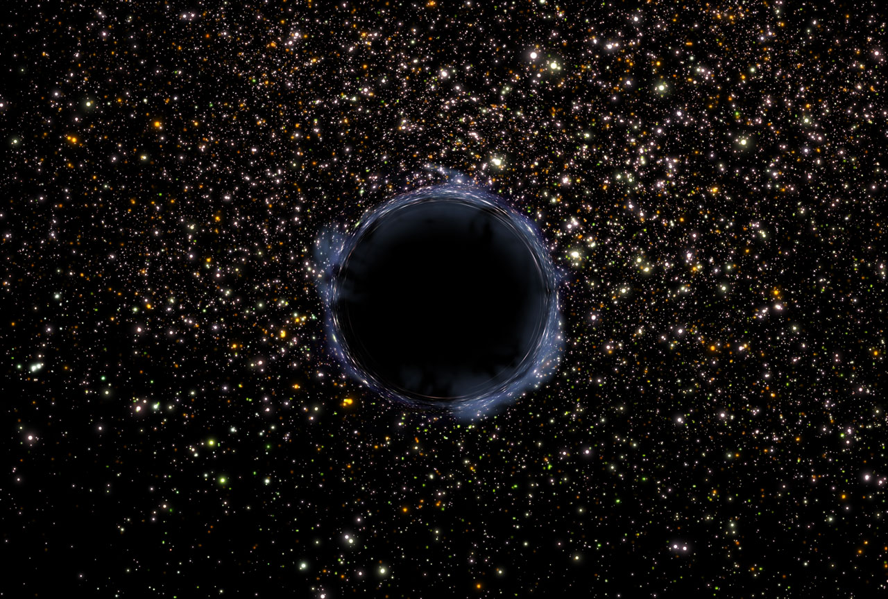
BlackHole, an extremely dense celestial body that has been theorized to exist in theuniverse. The gravitational field of a black hole is so strong that, if thebody is large enough, nothing, including electromagnetic radiation, can escapefrom its vicinity. The body is surrounded by a spherical boundary, called ahorizon, through which light can enter but not escape; it therefore appearstotally black. Theblack-hole concept was developed by the German astronomer Karl Schwarzschild in1916 on the basis of physicist Albert Einstein’s general theory of relativity.the radius of the horizon of a Schwarzschild black hole depends only on themass of the body, being 2.95 km (1.83 mi) times the mass of the body in solarunits (the mass of the body divided by the mass of the Sun). If a body iselectrically charged or rotating, Schwarzschild’s results are modified. An“ergosphere” forms outside the horizon, within which matter is forced to rotatewith the black hole; in principle, energy can be emitted fr

About Global Warming

Image
Doyou like warm weather? Do you wish it could be warmer still? Be careful whatyou wish for. The Earth may be moving in that direction. The demam isu is calledglobal warming. Not all scientists agree that global warming ishappening. Some say it is impossible to know if the climate is changingoverall. After all, temperatures vary from day to day and year to year. Mostscientists, however, say the isu terkini is up. The warmest days are warmer, thecoldest days not as cold. They point out that the ten warmest years of the lastcentury happened after 1980. The three hottest came after 1990. The hottestyear on record was 1998. These scientists say the Earth has warmed up about 1°Fahrenheit (0.6° Celsius) in the last 100 years. The rate of change, they say,is speeding up. A hundred years from now, the Earth may well be as much as tendegrees hotter! Peopleare changing the atmosphere. The changes started hundreds of years ago whenpeople began cutting down forests and burning the wood. The invent

5 Negara Terkaya di Dunia

Image
Baru-baru ini majalah Forbes mengeluarkan daftar negara terkaya pada dunia. Indikator yg dievaluasi adalah Pendapatan Domestik Brutto serta Dana Moneter Internasional. Berikut profil negara-negara tersebut. 1. Qatar Negara yang berada di Teluk Persia ini tercatat menjadi negara terkaya pada global. Dengan cadangan minyak  serta gas alam yg akbar serta jumlah penduduk yg hanya 1, 7 juta jiwa menjadikan pendapatan per kapita sebagai tinggi. Perkembangan infrastruktur pada negara ini sangat tinggi dan terkini. Berbagai gedung pencakar langit dibangun di tengah kota dan dengan desain yg cantik. Pendapatan perkapita mencapai 88.000 US Dollar.  2. Luxemburg Negara tetangga Belanda dan Belgia ini berada di urutan 2 lantaran penduduknya yang hanya 1/2 juta jiwa serta memiliki peraturan pajak dan perbankan yg ketat. Pendapatan per kapita mencapai lebih dari 81.000 US Dollar. 3. Singapura Negara pada Selat Malaka ini menduduki peringkat 3 dengan pendapatan perkapita mencapai 56.700 US Dollar. S

IstilahIstilah dalam gempa bumi

Image
Dalam memeriksa gempa bumi terdapat beberapa kata yang berkaitan dengan insiden tersebut yaitu: Baca juga: Pengertian, model konsep morfologi Contoh soal ulangan geografi bab hidrosfer Pengertian, contoh konsep aglomerasi Prinsip geografi serta penjelasannya Jenis-jenis proyeksi peta Geografi Eurasia dan fenomenanya Seismologi   : ilmu yg menyelidiki mengenai gempa bumi Seismograf   : alat pencatat gempa Seismogram : hasil catatan seismograph berupa grafik Hiposentrum : pusat gempa di pada bumi Episentrum   : pusat gempa di atas permukaan bumi sempurna diatas hiposentrum Homoseista : garis khayal dalam bagian atas bumi yang mencatat gelombang utama pada saat yang sama Pleistoseista: garis khayal pada permukaan bumi yang membatasi daerah dengan kerusakan terbesar akibat gempa   Isoseista    : garis pada peta yg menghubungkan wilayah dengan kerusakan yang sama dampak gempa Mikroseisme :gempa yang sangat kecil serta hanya dapat direkam oleh alat pencacat gempa Makroseisme  : gempa yg san

What is Caldera

Image
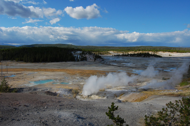
Caldera is huge basin shapped semicircular depression, calderas, like crater lake in Oregon USA, are often many kilimeters in diameter, produced when deep magma chambers inder a volacno empty out (during an eruption) and the overlying land collapses inward producing a topographic depression. Yellowstone Valley occupies one of the largest calderas in USA. Many geysers, hot springs, fumarol in the valley are related to groundwater circulating to depth being heated by shallow magma and mixing with volcanic gases that escape through minor cracks in the crust of the earth. Caldera may be relatively stable for tens or hundreds of thousand of years but often magma reeters the collapsed magma chamber and causes it to rise up or inflate. This forms a resurgent caldera which can produce a catastrophic volcano eruption. Baca Juga What Is Caldera What Is Caldera View What Is Caldera Santorini What Is Caldera Boundary What Is Caldera In English What Is Caldera View In Santorini What Is Caldera Vol

Mineral and Rock

Image
Definition of mineral naturally occuring inorganic solid characteristic crystalline structure definite chemical composition Definition of a rock "a solid aggregate (mixture) of minerals" The make up of solid matter on Earth Atom > Elements > Compounds > Minerals > Rocks (smallest)                                                    (largest) Mineral Characterisitc 1. Naturally formed  No substance created atificially is a mineral. Ex: plastic, steel, sugar 2. Inorganic Anything formed by a living organism and containing organic materials is not a minerals. Ex:  wood, plant, coal, shells 3. Solid Liquids and gases are not minerals. Ex: water, petroleum, lava, Oxygen 4. Characteristic crystalline structure must have an ordered arragement of atom displays repetitive geometric pattern in 3 D Baca Juga Mineral And Rock Show Mineral And Rock Store Mineral And Rock Mineral And Rock Store Near Me Mineral And Rock Shop Mineral And Rock Show Near Me Mineral And Rock Identi

Lirik I Have A Dream

Image
Bagi yang punya kenangan tentang lagu yg satu ini silahkan check it out, setiap orang punya mimpi serta mimpi itu sanggup terwujud dengan bisnis dan kerja keras WESTLIFE - I Have A Dream I have a dream, a song to sing  To help me cope with anything  If you see the wonder of a fairy tale  You can take the future even if you fail  I believe in angels  Something good in everything I see  I believe in angels  When I know the time is right for me  I'll cross the stream - I have a dream  I have a dream, a fantasy  To help me through reality  And my destination makes it worth the while  Pushing through the darkness still another mile  I believe in angels  Something good in everything I see  I believe in angels  When I know the time is right for me  I'll cross the stream - I have a dream  I'll cross the stream - I have a dream  I have a dream, a song to sing  To help me cope with anything  If you see the wonder of a fairy tale  You can take the future even if you fail  I believe i

Rumus Chord Lagu

Image
Musik adalah irama yg teratur. Menurut yg pernah Ane baca sih musik itu telah terdapat semenjak zaman purba gitu...tapi bukan mainin musik kaya gitar dll, mungkin batu atau apa ke yg sanggup dipukul trus membuat bunyi,,,hhh. Balik lagi ke musik jaman kini , dalam musik dikenal istilah chord. Chord merupakan formasi beberapa nada yang membentuk suara tertentu mulai menurut C, D, E, Em, Am serta lain sebagainya. Sebuah lagu pasti mempunyai chord tertentu tergantung suara vocalnya. Musik kan irama yg teratur,,namanya teratur jadi sebenarnya buat mencari akord sebuah lagu relatif gampang lantaran ada rumusnya kaya deret. Misalkan contoh kita ambil sebuah lagu pada internet yg sudah ada chordnya  contoh : C-Am-F-G Nah misalkan bunyi kalian nir masuk pada akord itu cara mengubahnya mudah, cukup hitung deret antar akordnya dari akord awal ,C ke Am  dihitung 6 kali, Am ke F 6 kali , F ke G 2 kali , berati rumus akor tadi VI-VI-II. Jadi klo misal suara engkau di G ya tinggal ganti hitung dari

Mengenal Bagian Gitar Klasik dan Nada

Image
Gitar merupakan alat musik yg tak jarang digunakan oleh banyak sekali kalangan. Hampir setiap orang niscaya pernah memainkan gitar, selain gampang dibawa kemana-mana harga gitar akustik pula relatif terjangkau oleh aneka macam kalangan. Untuk lebih tahu tentang bagian-bagian gitar klasik bisa ditinjau pada gambar dibawah ini.  Gitar akustik umumnya memiliki 6 senar, adapula yg mempunyai 7 senar tergantung kebutuhan penggunanya. Senar gitar klasik membuat nada yg tidak sama bila dipetik. Nada paling umum yang didapatkan gitar klasik sesudah disetel menurut posisinya paling atas adalah merupakan E-A-D-G-B-E.  Nada merupakan bunyi yg mempunyai frekuensi eksklusif. Nilai frekuensi dinyatakan dalam Hertz atau Hz. Jadi misalkan nada E memiliki frekuensi 329.63 Hz, nada B  memiliki Frekuensi 246.94 Hz dan sebagainya. Jadi patokan dasar sebuah nada merupakan nilai frekuensinya. Untuk itung-itungan rumusnya anda sanggup tanyakan langsung ke guru Fisika....untuk detail tentang 6 nada gitar klas

Lirik Separuh Aku Noah

Image
Bagi yang ingin mencari lirik serta chord Separuh Aku berdasarkan Noah silahkan ceck it out [intro] D Bm C#m-D D Em G 2x Bm Dan terjadi lagi Em G A kisah usang yang terulang kembali Bm D Kau terluka lagi Em G A dari cinta rumit yang kau jalani Em A Bm Aku ingin kau merasa A D A/C# Bm kamu mengerti saya mengerti kamu Em A D Aku ingin kau sadari G C F# cintamu bukanlah dia[chorus] B D#m G#m Dengar laraku, F# B D#m E suara hati ini memanggil namamu D#m C#m F# Lantaran separuh saya dirimu [int] Bm C#m-D D Em G Bm Ku terdapat di sini Em G A pahamilah kau tak pernah sendiri Bm D Karena saya selalu Em G A di dekatmu ketika engkau terjatuh Em A Bm Aku ingin kau merasa A D A/C# Bm kamu mengerti saya mengerti kamu Em A D Aku ingin kau sadari G C F# cintamu bukanlah dia[chorus] B D#m G#m Dengar laraku, F# B D#m E suara hati ini memanggil namamu D#m C#m F# Lantaran separuh saya dirimu[int] E [chorus] F# B D#m G#m Dengar laraku, F# B D#m E suara hati ini memanggil namamu D#m C

BentukBentuk Gunung Api

Image
Gunung api merupakan bentukan alam yg terbentuk karena kegiatan magma yg keluar berdasarkan perut bumi. Di bumi ini masih ada beranekaragam bentuk gunung barah. Berikut ini beberapa bentuk api yang terdapat pada muka bumi: Baca jua: Masalah kependudukan Indonesia jaman now Update kode promo quipper video terbaru Wilayah dan pewilayah pembangunan Perbedaan gletser serta gunung es Sumber daya alam pulau Jawa Jenis-jenis patahan kulit bumi 1. Stratovolcano Gunung barah ini berbentuk seperti kerucut. Puncak gunung barah ini semakin usang meningkat karena endapan erupsi lava serta bahan piroklastik dari kaldera gunung. Pembentukan stratovolcano ini terjadi pada zona subduksi. Di Indonesia gunung api strato paling banyak dijumpai. Contoh gunung api ini adalah Gunung Merapi, Gunung Tangkubanperahu, Gunung Semeru. 2. Cinder Volcano Gunung api ini memiliki karakteristik lubang kepundannya yg berbentuk seperti corong/kubah menggunakan kemiringan lereng yang curam. Gunung barah ini mempunyai le

Pemanfaatan Sistem Informasi Geografis

Image
Coba lihat smartphone mu, apakah ada fitur maps nya disana?. Di zaman now ini peran geografi telah sangat vital bagi kehidupan. Sistem Informasi Geografi sekarang sebagai sebuah kebutuhan manusia pada segala bidang.sistem Informasi Geografi (SIG) adalah suatu alat bantu pada menganalisa tanda-tanda geosfer. SIG sebagai satu disiplin ilmu yang berkembang pesat saat ini ditengah pesatnya teknologi pemetaan. Baca jua: Penjelasan pengertian pendekatan kelingkungan SIG sebagai dasar bagi para pembuat keputusan buat membuat sebuah kebijakan yg herbi perencaaan tat keruangan suatu wilayah. Geografi saat ini sebagai ilmu yg terintegrasi dengan teknologi personal komputer dan komunikasi. Tidak terdapat handphone andorid waktu ini yg tidak memiliki fitur GPS serta itu adalah galat satu kombinasi antara geografi serta teknologi. Baca jua: Kumpulan rumus hitung geografi Klasifikasi peta menurut skalanya Kode diskon quipper modern serta review Perbedaan geosentris serta heliosentris Faktor kepadat